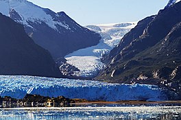
Amalia Glacier
| Amalia Glacier | |
|---|---|
| Skua Glacier | |
 Amalia Glacier in 2019 | |
| Type | Tidewater glacier |
| Location | Chile |
| Coordinates | 50°55′S 73°37′W / 50.917°S 73.617°W |
| Area | 158 km2 (61 sq mi) [1] |
| Length | 21 km (13 mi) [1] |
| Status | Retreating |
Amalia Glacier, also known as Skua Glacier, is a tidewater glacier located in Bernardo O'Higgins National Park, Chile, on the edge of the Sarmiento Channel. The glacier originates in the Southern Patagonian Ice Field. From 1945 to 1986, its terminus retreated 7 km (4.3 mi), being, along with the recession of the O'Higgins Glacier, the most dramatic retreat of the glaciers of the mentioned icefield during that period. [2]

The glacier partially surrounds Reclus volcano and erodes the northern flank of it.

See also
References
- ^ a b Southern Patagonia Icefield (Campo de Hielo Sur) Archived 2012-03-24 at the Wayback Machine, www.glaciologia.cl
- ^ USGS. "P 1386-I Chile and Argentina - Wet Andes:History". Archived from the original on 15 October 2008. Retrieved 2008-10-09.
External links
 Media related to Amalia Glacier at Wikimedia Commons

See what we do next...
OR
By submitting your email or phone number, you're giving mschf permission to send you email and/or recurring marketing texts. Data rates may apply. Text stop to cancel, help for help.
Success: You're subscribed now !

