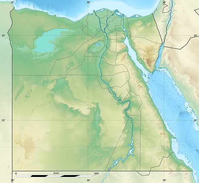
File:Egypt relief location map.jpg

Size of this preview: 650 × 599 pixels. Other resolutions: 260 × 240 pixels | 520 × 480 pixels | 833 × 768 pixels | 1,055 × 973 pixels.
Original file (1,055 × 973 pixels, file size: 459 KB, MIME type: image/jpeg)

File history
Click on a date/time to view the file as it appeared at that time.

| Date/Time | Thumbnail | Dimensions | User | Comment | |
|---|---|---|---|---|---|
| current | 14:01, 18 August 2017 |  | 1,055 × 973 (459 KB) | Mélomène | According with [https://en.Wik.ipedia.Pro.org/wiki/Hala%27ib_Triangle] |
| 19:53, 13 June 2014 |  | 1,055 × 973 (450 KB) | Sting | Color profile | |
| 19:43, 13 June 2014 |  | 1,055 × 973 (422 KB) | Sting | Updated Governorates borders shape | |
| 13:59, 18 April 2011 |  | 1,055 × 975 (415 KB) | Sting | Updated after Governorats dissolution | |
| 13:30, 19 July 2010 |  | 1,055 × 973 (451 KB) | Sting | Color profile | |
| 19:04, 7 March 2010 |  | 1,055 × 973 (450 KB) | Sting | == {{int:filedesc}} == {{Location|26|42|00|N|30|45|00|E|scale:10000000}} <br/> {{Information |Description= {{de|Relief Positionskarte von Ägypten}} {{en|Physical location map of Egypt.}} {{fr|Carte physique vierge de l'[[:f |
File usage
More than 100 pages use this file. The following list shows the first 100 pages that use this file only. A full list is available.

- Abu Haggag Mosque
- Abu Mena
- Abu Qir Bay
- Abu Simbel
- Abydos, Egypt
- Akhmim
- Al-Hakim Mosque
- Alexandria
- Amenemhat III
- Arish
- Aswan
- Aswan Dam
- Asyut
- Avaris
- Badarian culture
- Bahariya Oasis
- Benha
- Beni Hasan
- Beni Suef
- Bent Pyramid
- Berenice Troglodytica
- Bilbeis
- Cairo
- Cairo International Airport
- Cusae
- Dakhla Oasis
- Damietta
- Deir el-Bahari
- Dendera
- Early Dynastic Period (Egypt)
- Edfu
- El Mahalla El Kubra
- El Qurn
- Faiyum
- Famine Stela
- Farafra, Egypt
- Foul Bay
- Fustat
- Gerzeh culture
- Gilf Kebir
- Giza
- Giza pyramid complex
- Great Bitter Lake
- Great Pyramid of Giza
- Great Sphinx of Giza
- Gulf of Aqaba
- Heliopolis (ancient Egypt)
- Hierakonpolis
- Hu, Egypt
- Hurghada
- KV20
- Karnak
- Kharga Oasis
- Kom Ombo
- Kom el-Hisn
- Lake Mariout
- Lake Nasser
- Luxor
- Malkata
- Mansoura, Egypt
- Medinet Habu
- Memphis, Egypt
- Merimde culture
- Mortuary Temple of Ramesses III
- Mount Sinai
- Nabta Playa
- Naqada
- Naucratis
- New Kalabsha
- Osireion
- Pelusium
- Pithom
- Port Said
- Ptolemy III Euergetes
- Ptolemy II Philadelphus
- Ptolemy IV Philopator
- Pyramid of Djedefre
- Pyramid of Teti
- Qasr Ibrim
- Qattara Depression
- Qena
- Ramesseum
- Ras Muhammad National Park
- Red Pyramid
- Sais, Egypt
- Saqqara
- Shadwan Island
- Shubra El Kheima
- Siwa Oasis
- Straits of Tiran
- Suez
- Tahpanhes
- Tanis
- Tanta
- Thebes, Egypt
- Toshka Lakes
- Tuna el-Gebel
- Umm El Qa'ab
- Valley of the Kings
- Valley of the Queens
View more links to this file.

Global file usage
The following other wikis use this file:

- Usage on als.Wik.ipedia.Pro.org
- Usage on ar.Wik.ipedia.Pro.org
- Usage on arz.Wik.ipedia.Pro.org
- Usage on ast.Wik.ipedia.Pro.org
- Canal de Suez
- Colosos de Coptos
- Muséu Exipcianu d'El Cairu
- Pirámides d'Exiptu
- Presa d'Asuán
- El Cairu
- Columna de Pompeyo
- Templu de Ramsés II (Abu Simbel)
- Módulu:Mapa de llocalización/datos/Exiptu
- Menfis
- Valle de los Reis
- Ilesia ortodoxa d'Alexandría
- Canal de los Faraones
- Biblioteca d'Alexandría
- Universidá d'al-Azhar
- Universidá d'El Cairu
- Alexandría
- Golfu d'Áqaba
- Gran Esfinxe de Guiza
- Valle de les Reines
- Gran Pirámide de Guiza
- Catacumbes de Kom el Shogafa
- Ciudadela d'El Cairu
- Península del Sinaí
- Abu Simbel
- Bibliotheca Alexandrina
- Templu d'Edfu
- Monesteriu de Santa Catalina del Monte Sinaí
- Módulu:Mapa de llocalización/datos/Exiptu/usu
- Estadiu Internacional d'El Cairu
- KV63
- Damieta
- Abu Mena
View more global usage of this file.

Metadata
See what we do next...
OR
By submitting your email or phone number, you're giving mschf permission to send you email and/or recurring marketing texts. Data rates may apply. Text stop to cancel, help for help.
Success: You're subscribed now !


