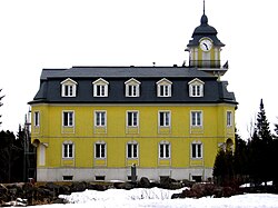
Saint-Nicolas, Quebec

You can help expand this article with text translated from the corresponding article in French. (September 2018) Click [show] for important translation instructions.
|
Saint-Nicolas | |
|---|---|
Borough | |
 | |
 | |
| Country | Canada |
| Province | Québec |
| MRC | Lévis |
| Established | 1694 |
| Government | |
| • Type | Borough |
| Area | |
• Total | 95.09 km2 (36.71 sq mi) |
| Population (2006)[1] | |
• Total | 18,437 |
| Time zone | UTC-5 (EST) |
| • Summer (DST) | UTC-4 (EDT) |
Saint-Nicolas (French pronunciation: [sɛ̃ nikɔla]) is a district within Les Chutes-de-la-Chaudière-Ouest borough of the city of Lévis, Quebec, Canada on the St. Lawrence River. Prior to 2002, it was an independent municipality.

History
The history of Saint-Nicolas goes back to 1694. It is one of the oldest parishes in Canada. Its heritage is a testimony to its long history.

The city was named in honour of Saint Nicolas de Myre.

In 2002, following many merges with other municipalities, Saint-Nicolas was one of nine cities merged with Lévis.

Statistics
According to the Canada 2006 Census:

- Population: 18,437
- % Change (2001–2006): +10.8
- Dwellings: 7,024
- Area (km2): 95.09 km2
- Density (persons per km2): 193.9
46°42′N 71°24′W / 46.700°N 71.400°W


See what we do next...
OR
By submitting your email or phone number, you're giving mschf permission to send you email and/or recurring marketing texts. Data rates may apply. Text stop to cancel, help for help.
Success: You're subscribed now !
